One Night In - Monhegan, Maine
Monhegan Island is a small island about 10 miles off the coast of Maine. The tallest coastal cliffs on the east coast, beautiful scenery, and Bortle 2 dark skies have drawn attention from visitors who tire of Acadia’s crowds. It is about the size of New York’s Central Park and has been an artist colony for generations and painters like Rockwell Kent, Edward Hopper, Robert Henri, George Bellows, and all of the Wyeths. These days painters are joined by photographers across the miles of trails and quaint village but the wild forests can be intimidating for first-time visitors.
Getting to Monhegan has some challenges. There is one ferry operating year round from Port Clyde (Monhegan Boat Line), with two other ferries during the summer: New Harbor (Hardy Boat Cruises) and Boothbay Harbor (Balmy Days). Note that the island does not allow for car ferries and there are minimal cars on the island itself. The few roads are dirt and are occupied primarily by foot traffic, golf carts, and occasional vehicles owned by island businesses.
Once you are there, there are a number of places to stay. For stays of one or two nights, I like the Monhegan House, I find it to be a good balance between cost and location; a more expensive but very central option is the Island Inn, the prominent hotel near the dock. If you're going out for longer, there are a lot of great homes for rent from a few different rental websites. Shining Sails is one of these; it is both a popular hub for weekly cottage rentals and operates a B and B. The island does not allow camping.
Trail maps are available on ferries, the dock, and various stores. The west harbor side of the island, where the village is located, has dirt roads. Much of the east side of the island has only narrow foottrails, which while well maintained, are minimally marked with 2” square green markers at either knee height or about 8 feet off the ground; they are easy to miss during the daylight hours but for the night photographer present an additional challenge if you haven’t seen them before. Some connections are not marked at all, fake trails often lead you to a cliff edge or a backyard, and it is easy to underestimate how long walking can take as maps do not take into account the vertical climbs that may have you reaching for tree roots. You should also be aware of the dangers along the coast, which include slippery rocks and cliffs. On the east coast of the island, sea rescue is difficult during the day and near impossible at night. It is highly recommended that you scout out locations to shoot during the day, if only to understand how long your hike will take you. Additionally, you will have a better understanding of where some trails end and private property begins.
The Walk
If you have only one night to shoot, weather will be your biggest challenge. On cloudy nights, I will typically stay close to the village itself, light painting down at Fish or Swim Beach, shooting closed public buildings, or capturing smaller details like lobster pots or buoys. This is a good thing to keep in mind for any of the cloudy nights you are likely to encounter on the coast of Maine.
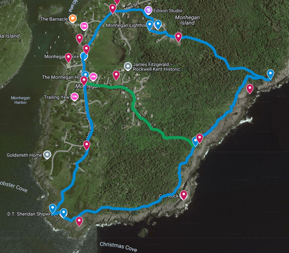
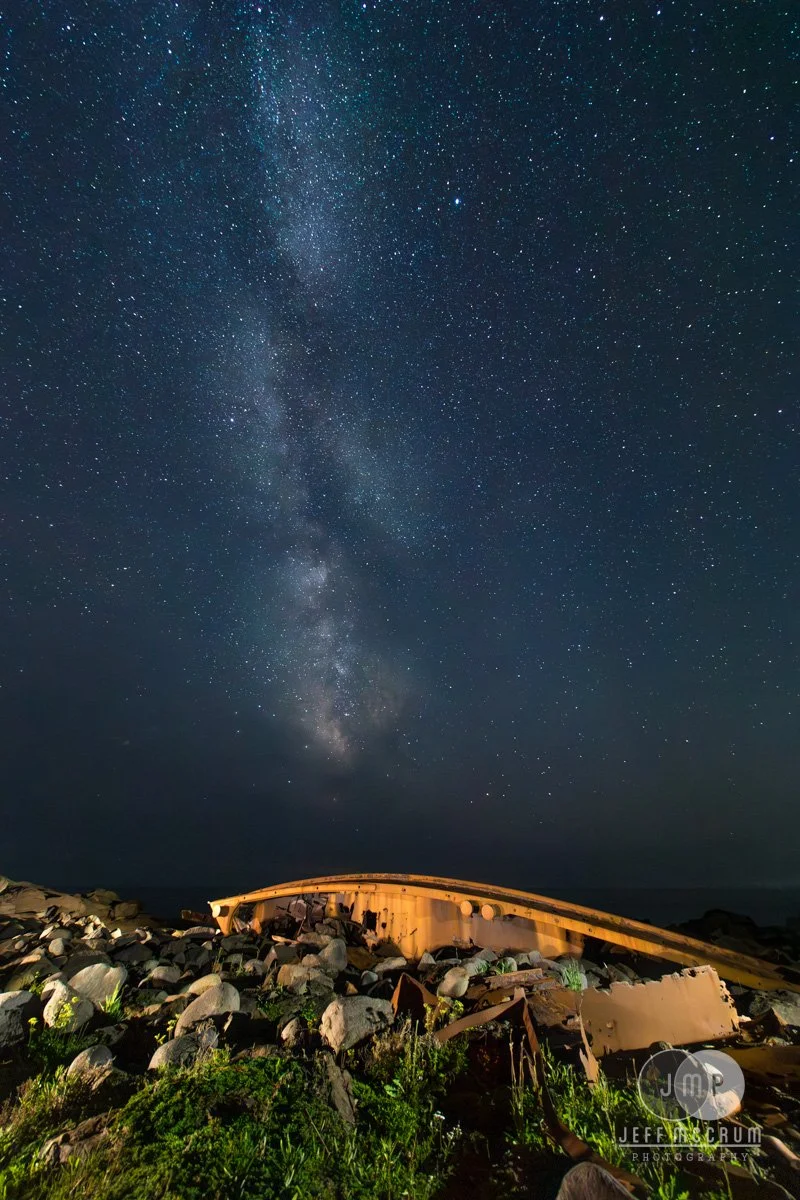
However, if the night is clear and you want to capture some stars or the moon, the coast is an excellent place to set the scene of the island as a whole. The east side of the island is typically deserted at night, resulting in beautiful sky conditions. You will need to be extremely careful around any cliff edges. But this route is designed to take you past the major highlights of Monhegan from a tugboat wreck from 1948, panoramic ocean views of the Milky Way, and the tallest cliffs on the East Coast.

You can then continue your walk along Trail 1 (the prominent trail cutting through the grass behind the wreck) toward the east to Christmas Cove, which is an excellent location for backlit waves at sunrise. Continue the trip past Gull Rock upward to Burnt Head. Gull Rock is an impressive location – a large round rocky promontory several meters high – but the back side drops off into a steep cliff and the approach is prone to lots of poison ivy, so I’d recommend against climbing it at night. Trail 1 continues along the coast for beautiful views, Trail 1A goes a little more inland but is slightly easier in the dark; the trick is making sure you're going the right way as 1 and 1A meet at various points along the coast. Trail markers, again, are 2" square, painted green, and not typically mounted at eye height, either about 8' up a tree or on a stick 18" off the ground. Burnt Head is a promontory dropping to a cliff that has some great views to the north with the sweeping foreground of Gull Cove and then the Milky Way off to the east when it is in season.


When you're done here you can pack up and head eastward down Trail 7 Whitehead. This will have a host of smaller trails leading off it at various points, especially as you get to the area with pines and Trails 1A, 6 Alden, and 9 Red Ribbon all converging within a few hundred feet. If you listen closely you'll hear the hum from the power plant up by the lighthouse to know you're heading in the right direction.
Your route on Trail 7 also slopes upward, which should be helpful as you find your way back towards the center of the island. Coming out of the woods will bring you onto the ballfield, an open plain with a power station to your right, texting containers to your left, and the lighthouse beams visible ahead from over the hill in front.
Going towards the lighthouse and museum you will come past the small ice house shack at the bottom, wind your way to the left and you'll find the stone lighthouse, keeper's quarters, and Monhegan museum. There's also a bell here that was helicoptered over from the adjacent Manana Island when the Coast Guard station over there closed. There are plenty of opportunities up here to shoot, and then it is a simple walk down the road behind the lighthouse with a left at the library to return back to the church.
Go make some art!
Starting behind the church and in front of the Monhegan House, take the road south towards Lobster Cove, with the bocce court and gardens on your right. You will pass the Trailing Yew on your right, followed by the brewery. Then the road will turn into a small pathway at the end continuing south towards the shore. As the trail opens out you will see Lobster Cove to your right, the wreck of the DT Sheridan to your left, and a life ring mounted to a wooden cross at the top of the rocks near the shore. The latter two are excellent light painting subjects. The sky glow off to the south is from Boston and there may be fishing boats shining bright lights into the water. Be sure to take care around the rocks, especially at low tide when they will be slippery.
Early Out Option:
To go home a little early is best down Trail 4 Burnt Head. You’ll still get the beautiful views from Burnt Head and the walk back is down a fairly large road. The trail is at the top of Burnt Head and marked with a little trail marker on a stick on your left. Your route down will take you past the grassy Horn Hill, a common sunset sightseeing spot, but also a great location for capturing the downtown area at night.
Otherwise, push on down into Gull Cove and then up the trail to White Head, an incredibly popular location for visitors due to the amazing views north, west, and south from the cliff, the large grassy plain provides plenty of nice rocks to rest against if you are taking a break while your camera captures some long exposures of the sky.


Late Night Eats
None, you will want to bring your own. Nite Nite Fatty’s, the dessert speakeasy on the Monhegan House porch closes by 8, it's generally the last thing open.
Late Night Bathrooms
Unfortunately Monhegan’s limited facilities also mean limited facilities. Aside from your residence the only public restrooms on the island are at the dock or behind the Novelty, located near the Monhegan House.